Settling of the Loudoun area began between 1725 and 1730, while it was still owned by Lord Fairfax. Permanent settlers came from Pennsylvania, New Jersey and Maryland. During the same period, settlers from eastern Virginia of English Cavalier stock came to lower Loudoun and established large tobacco plantations.
During the 1720's, a number of Quakers, Germans, Irish and Scots-Irish settled west of the Catoctin mountains. Quakers formed the settlements of Waterford, Goose Creek (now Lincoln), Harmony (now Hamilton) and Union (now Unison). From 1745 to 1760, Germans from Pennsylvania and Maryland formed the settlement at Lovettsville. After General Braddock's defeat by the French at Fort Duquesne in 1755, refugees from the Shenandoah Valley of Virginia settled in the western part of Loudoun County, south of Short Hill. Catoctin Church became the center of that settlement. (From LoudounHistory.org)
Loudoun’s agriculture flourished with its rich lands; growing tobacco in the east, and wheat, oats, rye, and corn in the west. During the Revolutionary War, the county contributed much of its grain to George Washington’s Continental Army, earning it the nickname “Breadbasket of the Revolution.” By 1775, Loudoun County had the largest militia in Virginia, and by the first census in 1790, it was Virginia’s most populous county. (From The Loudoun Museum)
When the British invaded Washington, D.C. during the War of 1812 and burned many of the public buildings, Loudoun’s county clerk hid critical federal documents, including the Constitution and Declaration of Independence, in the vault of a family home, Rokeby, southeast of Leesburg. In the 1820's, President James Monroe built a home in southern Loudoun that his friend, Thomas Jefferson, designed. At Oak Hill, the President would retire periodically from the hustle and bustle of Washington, and it was at Oak Hill, in 1823, he wrote the Monroe Doctrine. (From The Loudoun Museum)

Yardley Taylor's 1853 map includes drawings of well-known county scenes along the perimeter (LoudounHistory.org)
|
The first detailed map of Loudoun County — or of any part of the Virginia Piedmont or Northern Virginia — was surveyed and drawn by Yardley Taylor in 1852-53. Taylor's 36-by-51-inch "Map of Loudoun County, Virginia, from Actual Surveys" was printed on linen in muted red, yellow and green and black and cost $2, about twice the average daily wage. (From LoudounHistory.org) |
Waterford Mill
Click the photo for more information on mills and agriculture in Loudoun County. |
By 1860, Loudoun was one of Virginia’s most prosperous counties; its agricultural production at or near the top for such crops as corn and wheat. The county’s success in part was based on good land, but also on the labor of 5,501 slaves—one-quarter of the county’s population at the time. (From The Loudoun Museum) |
Example of Slave Quarters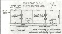
Click the photo for more information on slaves in Loudoun County.
|
|
Loudoun raised large numbers of men for the Confederate forces, but still was significantly divided. On the issue of secession, the county voted 1626 to 726 to secede from the Union, ratifying Virginia’s vote. Those voting against were heavily concentrated in northwestern Loudoun—in the areas settled by Quakers and Germans a century earlier. (From The Loudoun Museum)
A Civil War Chronology of Loudoun County, Virginia (click for a time line of Civil War events in Loudoun County) |

Loyalties in Loudoun County:
Red = Union
Grey = Confederate
|

Virginia before the Civil War
|
Mirroring the division in Loudoun County, many other counties were conflicted on the idea of secession. These conflicts eventually led to a formal split, thus creating West Virginia. |

Virginia and West Virginia after the Civil War
|
Here is an interesting tid-bit:
The Virginia-West Virginia boundary is still not final in some places. In 1991 the Virginia and West Virginia legislatures appropriated money for a boundary commission to look at 15 miles of fuzzy border between Loudoun County, Virginia and Jefferson County, West Virginia. Why? The Virginia attorney general had an assault prosecution thrown out of court; because the boundary is so fuzzy, they couldn't prove the crime took place in Virginia.
(From VirginiaPlaces.org)
After the Civil War, a number of small African-American communities sprang up near former plantations. With the expansion of a railroad west through Loudoun, communities such as Ashburn, Hamilton, Purcellville, and Round Hill, grew along the route as they became business centers for farmers and summer vacation havens for Washingtonians. Loudoun’s agriculture continued to flourish, adapting to changing markets near the turn of the century by switching from chop farming to dairy and raising beef cattle and fine horses. A number of America’s wealthy bought former plantations in Loudoun and turned them into showplaces known for their architecture and livestock. Oatlands and Morven Park are two that are open to the public today.
(From The Loudoun Museum)

Oatlands Plantation
|

Morven Park
|
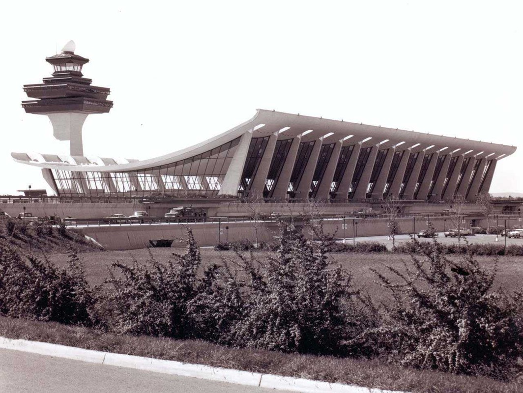
Dulles Airport (click the photo for the history behind the land)
|
In the 1960's, Loudoun began to grow substantially, growth that has continued to this day, bringing a six fold increase in population in a forty-year span. The building of Dulles International Airport in the early 1960's fueled economic development. In its wake, a gradual hi-tech boom came to the eastern Loudoun-western Fairfax area. Accordingly, many have moved to eastern Loudoun and become residents of planned communities such as Sterling Park, Sugarland Run, Cascades, and Ashburn Farms, making that section a veritable part of the Washington suburbs. Others have moved to the county seat or to the small towns and rural communities of the Loudoun Valley. (From The Loudoun Museum)
Click here for an interesting article on the history of Ashburn Village. |
Next...Loudoun in the Civil War
